On June 1, 2020, invited by Surveying and Mapping Engineering Institute, Dr. Kun Qin, Deputy Dean of Wuhan University, Dr. Jiayuan Lin, Southwest University, and Bin Wang, Professorate Senior Engineer of Chongqing Geomatics and Remote Sensing Center brought three wonderful online academic reports for teachers and students of our school and other universities. The reports were held via the Tencent Meeting App. The topics of these three reports were: “Remote Sensing Spatio-Temporal Big Data and Spatial Scientific Social Analysis”, “Aboveground Tree Biomass Estimation of Sparse Subalpine Coniferous Forest with UAV Oblique Photography”, and “Preliminary Survey on Planning and Remote Sensing Monitoring of Natural Resources”. Associate Professor Yali Zhang presided over this report.
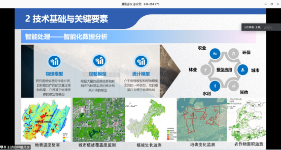
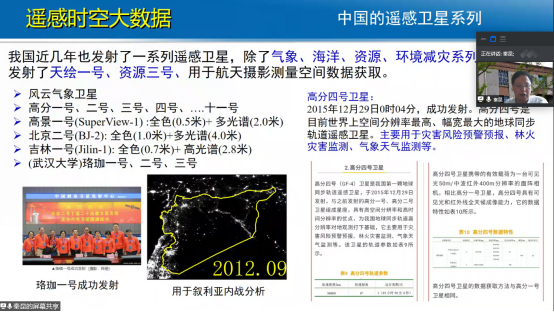
First, starting with the concept of remote sensing and what remote sensing can do, Dr. Kun Qin introduced the fourth paradigm of scientific research, remote sensing spatio-temporal big data, ideas of spatio-temporal big data construction, abnormal discovery of remote sensing images based on deep learning, the necessity and feasibility of spatial humanities and social analysis. Then he described the method of abnormal target discovery based on deep learning for unmanned areas, the assessment method of the impact of Syrian war based on luminous remote sensing big data, the evaluation method of regional unbalanced development in China based on luminous remote sensing big data, and the method of international relationship network analysis based on GDELT. In the end, Dr. Kun Qin gave detailed replies to the questions raised by online attendants.
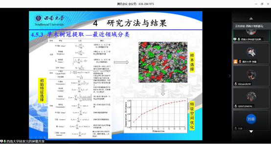
Next, starting from the significance and scales of forest biomass research, Dr. Jiayuan Lin introduced various methods of forest biomass estimation and the problems in traditional methods. He presented the estimation method of aboveground forest biomass based on UAV oblique photography. Dr. Jiayuan Lin took a typical subalpine coniferous forest in the source region of Min River as the study area, and took local fir trees as the research objects. He introduced in detail the process of obtaining the height of the individual tree using the UAV oblique photography technology and its accuracy, and the method of forest aboveground biomass estimation and its accuracy. At last, Dr. Jiayuan Lin gave detailed replies to the questions raised by online attendants.
In the end, starting with the ten functions related to the application of remote sensing technology in the 21 functions of Chongqing Planning and Natural Resources Bureau, Mr. Bin Wang, Professorate Senior Engineer, introduced the overall technical framework of planning and remote sensing monitoring of natural resources, including acquisition of remote sensing data, production and application of remote sensing products and administrative decision assistance. Combining with the projects his work unit has done, he introduced various cases of remote sensing investigation and monitoring applications in detail, which included 2D and 3D integrated work base map, space usage monitoring and supervision, ecological protection and restoration, comprehensive disaster prevention and inspection and law enforcement of natural resource planning. At last, Mr. Bin Wang gave detailed replies to the questions raised by online attendants.